
| Date | Name of Vessel |
Type of Vessel |
Tonnage JANAC |
Tonnage Alden |
Location | Assessment JANAC |
Assessment Alden |
|---|---|---|---|---|---|---|---|
| 17 June 1943 | Myoko Maru | Passenger/Cargo | 5,087 | 5,086 | 2-03S, 153-44E | Sunk | Sunk |
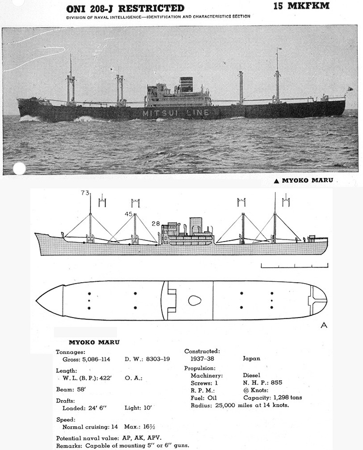
Image courtesy of History on CD-ROM.
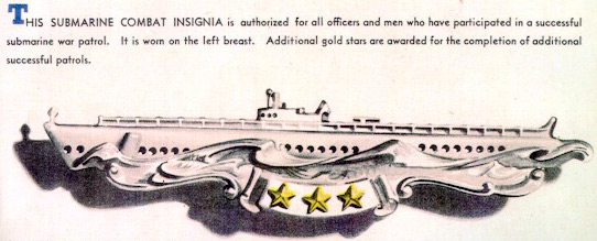
Award of Submarine Combat Insignia for this patrol is authorized.
(A) Prologue
(B) Narrative
(C) Weather
(D) Tidal Information
(E) Navigational Aids
(F) Ship Contacts
(G) Aircraft Contacts
(H) Attack Data
(I) Mines
(J) Anti Submarine Measures and Evasive Tactics
(K) Major Defects and Damage
(L) Radio
(M) Radar
(N) Sound Gear and Sound Conditions
(O) Density Layers
(P) Health, Food, and Habitability
(Q) Personnel
(R) Miles Steamed - Fuel Used
(S) Duration
(T) Factors of Endurance Remaining
(U) Remarks
Returned from fifth war patrol on May 13, 1943. Normal refit by U.S.S. FULTON at Brisbane, Australia. Ready for sea, June 4, 1943. Fired 15 rounds of 4"/50 caliber at a towed target; held sound listening test; conducted three night radar training approaches; and made sound runs for destroyer. Made deep dive on June 6, 1943, and developed leak in conning tower eyeport. Returned to Brisbane for repairs. Ready for sea, June 7, 1943.
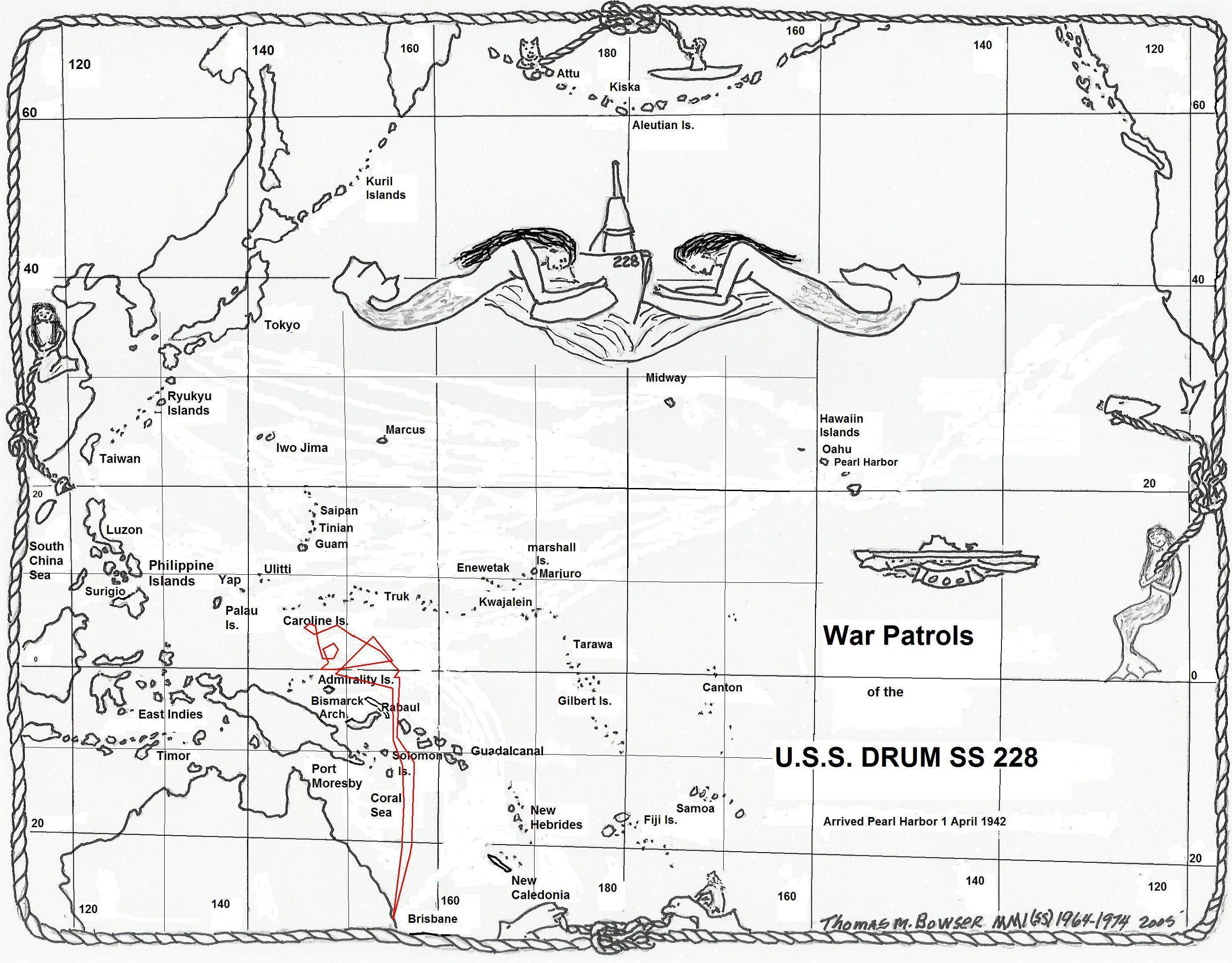
Mission: DESTROY ENEMY VESSELS in Solomons - Bismarcks - New Guinea Area.
| 7 June | |
| 1250 (K) | Underway from alongside U.S.S. FULTON in company with HMAS BENALLA. |
| 2130-2230 | Conducted night radar runs. |
| 8 June | |
| 0235 (K) | Obtained "ghost" echo on radar 130° to right of escort at same range. This is the first distinct "ghost" echo ever obtained by us. |
| 0801 | Commenced sound runs for escort, followed by successful deep dive. |
| 1309-1624 | Conducted four submerged approaches. On the dive for the fourth approach, power on the port screw was lost. This casualty was caused by the failure of the 75% motor field interlock. This the fourth successive patrol on which this casualty has occurred. |
| 1624 | Set course for HORSE. Escort returned to port. |
| 1200 |
POSIT: LAT. 26-12.0 S. LONG. 155-15.0 E.
DIST: 229.9 FUEL: 1699 |
| 9 June | |
| Conducted three training dives. | |
| 1613 (K) | Blew negative tank flood valve gasket on third dive. Experience proves that the "T" shaped gasket can be blown! |
| 1200 |
POSIT: LAT. 21-52.5 S. LONG. 156-05.0 E.
DIST: 283.2 FUEL: 2729 |
| 10 June | |
| Conducted three training dives. Diving time is affected but little by los of negative tank. Practiced going deep without use of negative. | |
| 1200 |
POSIT: LAT. 16-59.0 S. LONG. 156-35.0 E.
DIST: 319.0 FUEL: 2918 |
| 11 June | |
| 0530 (K) | Submerged on first all day dive. |
| 1805 | Surfaced. |
| 1200 |
POSIT: LAT. 13-03.0 S. LONG. 156-56.5 E.
DIST: 249.7 FUEL: 2280 |
| 12 June | |
| 0515 (K) | Submerged. |
| 0900 | Changed to minus eleven (-11) zone time. |
| ALL TIMES HEREAFTER ARE "LOVE". | |
| 1917 (L) | Surfaced. |
| 1200 |
POSIT: LAT. 10-22.0 S. LONG. 156-47.0 E.
DIST: 191.4 FUEL: 1624 |
| 13 June | |
| 0605 (L) |
Submerged. Serviced torpedoes. |
| 1934 | Surfaced. |
| 1200 |
POSIT: LAT. 8-36.0 S. LONG. 155-15.0 E.
DIST: 178.8 FUEL: 1685 |
| 14 June | |
| 0555 (L) | Submerged. |
| 1940 | Surfaced. |
| 1200 |
POSIT: LAT. 6-50.0 S. LONG. 154-02.0 E.
DIST: 179.8 FUEL: 1588 |
| 15 June | |
| 0215 (L) | Sighted Buka Island, distance about 25 miles. |
| 0540 | Submerged. |
| 1800 | Sighted Feni Island, distance 45 miles. No enemy activity of any kind encountered while passing between the islands. |
| 1947 | Surfaced. |
| 1200 |
POSIT: LAT. 4-18.0 S. LONG. 154-37.0 E.
DIST: 174.4 FUEL: 1396 |
| 16 June | |
| 0530 (L) | Entered assigned area in Lat. 2-00.0 S., Long. 154-01.0 E. |
| 0542 | Submerged. |
| 1945 | Surfaced. |
| 1200 |
POSIT: LAT. 01-45.0 S. LONG. 154-01.0 E.
DIST: 174.3 FUEL: 1486 |
| 17 June | |
| 0200 (L) | Sighted three ships bearing 220°(T) distance 20,000 yards. (Contact No. 1) (Lat. 1-12.0 S., Long. 153-40.0 E.). Commenced tracking with the radar at ranges of 13,500 yards to 21,300 yards. Determined convoy base course as 125°(T), speed 9 knots, until 0400, then 190°(T). |
| 0548 | Submerged and commenced closing the track of the convoy at high speed. |
| 0625 | Sighted two freighters and one Mutsuki class destroyer, bearing 005°(T), distance 10,000 yards, angle on the bow 0°. Manned battle stations (Attack No. 1) (Lat. 2-03.0 S., Long. 153-44.0 E.) |
| 0655-51" | Fired #7 tube. |
| 0656-00" | Fired #8 tube. |
| 0656-08" | Fired #9 tube. |
| 0656-15" | Fired #10 tube. |
| 0656-30" | Went to deep submergence and commenced evasive tactics. |
| 0656-59" | #7 torpedo hit. |
| 0657-07" | #8 torpedo hit. |
| 0657-12" | #9 torpedo hit. |
| 0702 | First of 3 depth charges, not close. |
| 0703 | 6 depth charges, close astern, overhead, forcing the boat down about 15 feet to 310 feet. |
| 0715 | Bulkheads of torpedoed ship collapsing. |
| 0811 | 2 depth charges, distant, total 11. |
| 0935 | Returned to periscope depth. Nothing in sight. |
| 1035 | Heard 4 aircraft bombs, not close, but did not see the plane. (Aircraft Contact No. 1) (Lat. 1-55.0 S., Long. 153-54.5 E.) |
| 2010 | Surfaced. |
| 1200 |
POSIT: LAT. 1-50.0 S. LONG. 153-57.0 E.
DIST: 161.5 FUEL: 1365 |
| 18 June | |
| 0546 (L) | Submerged. |
| 1948 | Surfaced. |
| 1200 |
POSIT: LAT. 00-01.0 S. LONG. 154-07.0 E.
DIST: 152.4 FUEL: 1119 |
| 19 June | |
| 0534 (L) | Submerged. |
| 1945 | Surfaced. |
| 1200 |
POSIT: LAT. 00-38.5 N. LONG. 154-03.0 E.
DIST: 99.7 FUEL: 444 |
| 20 June | |
| 0543 (L) | Submerged. |
| 1946 | Surfaced. |
| 1200 |
POSIT: LAT. 00-47.0 N. LONG. 153-00.0 E.
DIST: 97.5 FUEL: 334 |
| 21 June | |
| 0548 (L) | Submerged. |
| 2005 | Surfaced. |
| 1200 |
POSIT: LAT. 2-15.5 N. LONG. 151-47.0 E.
DIST: 139.6 FUEL: 682 |
| 22 June | |
| 0550 (L) | Submerged. |
| 2005 | Surfaced. |
| 1200 |
POSIT: LAT. 3-09.0 N. LONG. 149-16.0 E.
DIST: 175.5 FUEL: 1390 |
| 23 June | |
| 0600 (L) |
Submerged. Serviced torpedoes, and found one exploder completely flooded. Made magnetic feature inoperative. |
| 2020 | Surfaced. |
| 1200 |
POSIT: LAT. 2-53.0 N. LONG. 147-34.0 E.
DIST: 148.4 FUEL: 1159 |
| 24 June | |
| 0009 (L) | Sighted two dark objects bearing 095°(T), distant about 8000 yards. (Contact No. 2) (Lat. 3-35.0 N., Long. 147-23.0 E.). The radar was unable to obtain a contact. |
| 0025 | Commenced closing to investigate. One object may have been a patrolling destroyer or the U.S.S. GREENLING; while the other could not be identified as a ship. That both objects were clouds is not impossible. The rising moon, and visibility conditions unfavorable to us made further development of the contact impracticable. |
| 0130 | Cleared the area to the westward. |
| 0603 | Submerged. |
| 2020 | Surfaced. |
| 1200 |
POSIT: LAT. 3-38.0 N. LONG. 146-39.0 E.
DIST: 90.4 FUEL: 348 |
| 25 June | |
| 0610 (L) | Submerged. |
| 2022 | Surfaced. |
| 1200 |
POSIT: LAT. 3-30.0 N. LONG. 146-44.0 E.
DIST: 96.9 FUEL: 363 |
| 26 June | |
| 0612 (L) | Submerged. |
| 2015 | Surfaced. |
| 1200 |
POSIT: LAT. 3-29.0 N. LONG. 146-40.0 E.
DIST: 93.2 FUEL: 345 |
| 27 June | |
| 0610 (L) | Submerged. |
| 2022 | Surfaced. |
| 1200 |
POSIT: LAT. 3-23.0 N. LONG. 147-09.0 E.
DIST: 94.3 FUEL: 346 |
| 28 June | |
| 0620 (L) | Submerged. |
| 2020 | Surfaced. |
| 1200 |
POSIT: LAT. 1-55.0 N. LONG. 148-55.5 E.
DIST: 149.3 FUEL: 747 |
| 29 June | |
| 0700 (L) | Commenced surface patrol to westward. |
| 1921 | Submerged for trim dive. |
| 1957 | Surfaced. |
| 1200 |
POSIT: LAT. 1-02.5 N. LONG. 149-17.5 E.
DIST: 156.7 FUEL: 876 |
| 30 June | |
| 0700 (L) | Commenced surface patrol to westward. |
| 1920 | Submerged for trim dive. |
| 1950 | Surfaced. |
| 1200 |
POSIT: LAT. 00-57.0 N. LONG. 149-12.0 E.
DIST: 224.2 FUEL: 1213 |
| 1 July | |
| 0700 (L) | Commenced surface patrol to westward. |
| 1920 | Submerged for trim dive. |
| 1950 | Surfaced. |
| 1200 |
POSIT: LAT. 2-45.0 N. LONG. 149-13.5 E.
DIST: 266.7 FUEL: 1636 |
| 2 July | |
| 0700 (L) | Commenced surface patrol to westward. |
| 1925 | Submerged for trim dive. |
| 1950 | Surfaced. |
| 1200 |
POSIT: LAT. 1-58.5 N. LONG. 149-19.5 E.
DIST: 223.5 FUEL: 1517 |
| 3 July | |
| 0700 (L) | Commenced surface patrol to westward. |
| 1924 | Submerged for trim dive. |
| 1953 | Surfaced. |
| 1200 |
POSIT: LAT. 1-51.0 N. LONG. 149-09.5 E.
DIST: 223.7 FUEL: 1206 |
| 4 July | |
| 0700 (L) | Commenced surface patrol to westward. |
| 1915 | Submerged for trim dive. |
| 1953 | Surfaced. |
| 1200 |
POSIT: LAT. 2-04.0 N. LONG. 148-13.5 E.
DIST: 222.7 FUEL: 1228 |
| 5 July | |
| 0700 (L) | Commenced surface patrol to westward. |
| 1900 | Submerged for trim dive to 200 feet. |
| 1950 | Surfaced. |
| 1200 |
POSIT: LAT. 1-08.0 N. LONG. 148-15.5 E.
DIST: 217.4 FUEL: 1221 |
| 6 July | |
| 0355 (L) | Made radar contact bearing 290°(T) at 5000 yards, (Contact No. 3) (Lat. 1-20.0 N., Long. 150-10.0 E.). Lost contact at 7200 yards. Closed to investigate but no further radar contact was obtained, nor was the target ever sighted. |
| 0700 | Commenced surface patrol to westward. |
| 1115 | Sighted a floating mine (Lat. 1-35.0 N., Long. 150-15.0 E.) |
| 1155 | Fired 180 rounds of 20 mm ammunition and exploded the mine at a range of 200 yards. The only casualty was the junior officer of the deck, who suffered a small scratch on his finger from a piece of shrapnel. |
| 1253 |
Made aircraft contact on SD radar at 12 miles. Plane not sighted. Submerged (Aircraft Contact No. 2) (Lat. 1-37.0 N., Long. 150-05.0 E.) |
| 1353 | Surfaced and resumed surface patrol. |
| 1200 |
POSIT: LAT. 1-35.0 N. LONG. 150-13.0 E.
DIST: 252.9 FUEL: 1850 |
| 7 July | |
| 0701 (L) | Submerged. |
| 1330 | Heard echo ranging bearing 235°(T), on 18 kilocycles at about 38,000 yards. (Contact No. 4) (Lat. 00-50.0 N., Long. 147-12.0 E.). |
| 1350 | Heard screws bearing 233°(T) at about 30,000 yards. Commenced closing track at high speed. Manned battle stations submerged. |
| 1357 | Sighted plane over target group. (Aircraft Contact No. 3) (Lat. 00-50.0 N., Long. 147-12.0 E.). |
| 1411 | Sighted masts and stack of a tanker, angle on the bow 80° port, range 24,000 yards. |
| 1515 | Secured from battle stations submerged; unable to close to less than 16,000 yards. |
| 1607 | Lost contact with echo ranging at about 40,000 yards. |
| 1750 | Heard two sharp explosions, resembling torpedo explosions. |
| 1800 | Surfaced, and headed down track of tanker at high speed. Sent contact report. |
| 2145 | Sighted smoke bearing 150°(T) (Contact No. 5) (Lat. 00-37.0 N., Long. 148-13.0 E.). Commenced closing to investigate. |
| 2230 | Sighted red light. |
| 2348 | Made radar contact on ship at 16,200 yards. |
| 1200 |
POSIT: LAT. 00-53.0 N. LONG. 147-16.0 E.
DIST: 310.7 FUEL: 4343 |
| 8 July | |
| 0020 (L) | Identified ship as hospital ship properly lighted in accordance with the Hague Convention Agreement of 1907. Changed course to continue search for tanker in the direction of Kavieng. |
| 0616 | Submerged. |
| 2015 | Surfaced. |
| 1200 |
POSIT: LAT. 00-59.5 S. LONG. 148-48.5 E.
DIST: 189.2 FUEL: 1757 |
| 9 July | |
| 0623 (L) |
Submerged. Serviced torpedoes. |
| 2002 | Surfaced. |
| 1200 |
POSIT: LAT. 00-15.0 S. LONG. 150-54.0 E.
DIST: 158.7 FUEL: 1163 |
| 10 July | |
| 0700 (L) | Commenced surface patrol to westward. |
| 1925 | Submerged for trim dive. |
| 1950 | Surfaced. |
| 1200 |
POSIT: LAT. 1-59.5 N. LONG. 153-00.0 E.
DIST: 232.5 FUEL: 1716 |
| 11 July | |
| 0700 (L) | Commenced surface patrol to westward. |
| 1200 |
POSIT: LAT. 3-00.0 N. LONG. 151-14.0 E.
DIST: 232.5 FUEL: 1311 |
| 12 July | |
| 0626 (L) | Submerged. |
| 2007 | Surfaced. |
| 1200 |
POSIT: LAT. 1-08.0 N. LONG. 150-13.5 E.
DIST: 255.4 FUEL: 1944 |
| 13 July | |
| 0626 (L) | Submerged. |
| 1955 | Surfaced. |
| 1200 |
POSIT: LAT. 00-06.0 N. LONG. 149-09.5 E.
DIST: 101.2 FUEL: 359 |
| 14 July | |
| 0502 (L) | Submerged. |
| 0920 |
Sighted smoke bearing 304°(T). (Contact No. 6) (Lat. 1-24.0 S., Long. 147-59.5 E.). Commenced the approach. |
| 0938 | Heard echo ranging on 17 kilocycles. |
| 0954 | Heard screws of enemy convoy. |
| 1022 | Sighted masts of four ships, with two angles on the bow port, and two, starboard. Manned battle stations submerged. |
| 1045 | Three escort vessels in sight. |
| 1100 | When the range of the left most ship in the convoy closed to 6500 yards, 2800 yards to the track, the convoy changed base course 60° to the right to 170°(T). |
| 1115 | Secured from battle stations submerged, unable to close the range to less than 5800 yards. The leading freighter (6500 tons) (KKFKK) was listed slightly to port, damaged aft. The other three freighters (4000-5000 tons) (MFM, well dock) appeared to be undamaged. |
| 1420 | Sighted two large aircraft over the convoy. (Aircraft Contact No. 4) (Lat. 1-30.0 S., Long. 148-05.0 E.). |
| 2005 | Surfaced. |
| 1200 |
POSIT: LAT. 1-28.0 S. LONG. 148-00.0 E.
DIST: 164.3 FUEL: 1355 |
| 15 July | |
| 0634 (L) | Submerged. |
| 2006 | Surfaced. |
| 1200 |
POSIT: LAT. 00-11.5 S. LONG. 148-13.5 E.
DIST: 102.7 FUEL: 356 |
| 16 July | |
| 0625 (L) | Submerged. |
| 2003 |
Surfaced. Received orders to terminate patrol. Set course to southeast. |
| 1200 |
POSIT: LAT. 00-02.5 N. LONG. 148-22.5 E.
DIST: 103.3 FUEL: 359 |
| 17 July | |
| 0626 (L) | Submerged. |
| 2000 | Surfaced. |
| 1200 | POSIT: LAT. 1-04.0 S. LONG. 150-52.0 E. |
| 18 July | |
| 0345 (L) | Sighted Lihir Island, distant 45 miles. |
| 0625 | Submerged. |
| 0740 | Sighted Tanga Island, distant 45 miles. |
| 2002 | Surfaced. |
| 1200 |
POSIT: LAT. 2-54.0 S. LONG. 153-32.0 E.
DIST: 197.9 FUEL: 2021 |
| 19 July | |
| 0236 (L) | Sighted Green Island, distant 16 miles. |
| 0515 | Submerged. |
| 1114 | Sighted four-engined monoplane (Aircraft Contact No. 5) (Lat. 5-05.0 S., Long. 154-00.0 E.). |
| 2002 |
Surfaced. No enemy surface units were encountered while passing between the islands. |
| 1200 |
POSIT: LAT. 5-08.0 S. LONG. 153-59.0 E.
DIST: 174.3 FUEL: 1314 |
| 20 July | |
| 0522 (L) | Received orders to search for life raft with three RAAF filers aboard. Commenced closing position at 19 knots on course 322°(T). |
| 0730 | Sighted enemy submarine on the surface, bearing 083°(T), distant 10 miles, (Contact No. 7) (Lat. 7-24.0 S., Long. 153-49.0 E.). His course was 160°(T), and he passed out of sight rapidly. |
| 0740 | Sighted plane bearing 310°(T), distant 11 miles (Aircraft Contact No. 6) (Lat. 7-22.0 S., Long. 153-47.0 E.). This plane was later identified as an RAAF "Beaufighter". |
| 0800 | Sighted enemy submarine on surface, bearing 081°(T), distant 10 miles (Contact No. 8) (Lat. 7-07.0 S., Long. 153-35.0 E.). This submarine was sighted because of his heavy black exhaust smoke. His course was 315°(T), parallel to the Drum, but he dropped astern and disappeared rapidly. |
| 0905 | Exchanged recognition signals with the "Beaufighter" (A-OH). Was informed that the life raft could not be located. Told him of the enemy submarines to the eastward, and off he went. His later actions did not indicate that he had sighted any enemy submarines, however. |
| 1030 | Sighted a second plane, unidentified, though similar to the "Beaufighter" in appearance, bearing 330°(T), distant 12 miles. (Aircraft Contact No. 7) (Lat. 6-48.0 S., Long. 153-16.5 E.). |
| 1035 | Commenced search in area to westward of reported position of raft. |
| 1046 | Sighted object resembling a submarine, bearing 331°(T), distant 5 miles. |
| 1052 | Submerged and commenced closing to investigate. |
| 1220 | Identified object as a large tree. Set a watch on the aircraft frequency, 7105 Kcs., on the periscope antenna at 50 feet. Heard numerous signals, but nothing further on the search for the raft. |
| 1930 | Surfaced and continued search for the raft. |
| 1200 |
POSIT: LAT. 6-42.0 S. LONG. 153-14.0 E.
DIST: 274.1 FUEL: 3770 |
| 21 July | |
| 0147 (L) | Received orders to abandon search. Set course for Brisbane. |
| 0615 | Submerged. |
| 1955 |
Surfaced POSIT: LAT. 8-26.0 S. LONG. 153-40.0 E. DIST: 186.1 FUEL: 1651 |
| 22 July | |
| 0620 (L) | Submerged. |
| 1230 | Sighted Rossel Island bearing 258°(T) distant 30 miles. |
| 1944 | Surfaced. |
| 1200 |
POSIT: LAT. 11-16.0 S. LONG. 154-39.0 E.
DIST: 201.1 FUEL: 2178 |
| 23 July | |
| Commenced cruising on the surface during daylight hours. | |
| 1200 |
POSIT: LAT. 15-12.0 S. LONG. 153-53.0 E.
DIST: 242.6 FUEL: 3133 |
| 24 July | |
| 1358 (L) | Submerged, conducted one hour battery discharge. Averaged ten knots during the discharge. |
| 1735 | Surfaced. |
| 1200 |
POSIT: LAT. 20-18.0 S. LONG: 154-51.0 E.
DIST: 330.0 FUEL: 3471 |
| 25 July | |
| 1400 (L) | Submerged for training dive. |
| 1518 | Surfaced. |
| 1200 |
POSIT: LAT. 24-20.0 S. LONG. 154-32.0 E.
DIST: 271.9 FUEL: 2760 |
| 26 July | |
| 0050 (L) | Made radar contact on Allied convoy bearing 268°(T) distant 28,000 yards, repeat, 28,000 yards. (Lat. 26-10.0 S., Long. 154-10.0 E.). |
| 0110 | Lost contact at 29,000 yards. |
| 0412 | Exchanged recognition signals with U.S.S. BALAO. (Lat. 26-35.0 S., Long. 153-55.0 E.) |
| 0448 | Sighted Cape Moreton light bearing 230°(T), distant 25 miles. |
| 0900 | Changed to minus ten (-10) zone time. |
| 1030 (K) | Moored to U.S.S. FULTON. |
The weather during the entire time in area bounded by 2° S. to 4° N. and 146° E. to 154° E. was unfavorable for submerged attack. The unfavorable conditions included; calm to glassy seas, little or no wind, frequent rain squalls with attendant poor visibility, and partly cloudy skies. The barometer was steady at 29.76. On one, and only one, day out of thirty-three, was there a semblance of whitecaps.
In the patrol area, 2° S. to 4° N. and 146° E. to 154° E., currents of one-half knot setting east to southeast were experienced at times.
In the area, westward of the Solomon Islands, from 10° S. to the pass between New Ireland and Buka, currents of 1.0 to 1.5 knots setting southeasterly were encountered.
None sighted.
| No. | Time | Date | Lat. | Long. | Type | Course | Speed RPM | Initial Range | Contact By | Masthead Height | Length |
|---|---|---|---|---|---|---|---|---|---|---|---|
| 1. | 0200 (L) | 17 Jun. | 1-12.0 S | 153-40.0 E | 2 Freighters 1 Mutsuke DD |
125°(T) 180°(T) |
9 Kts 95 RPM |
20,000 yds. | Sight Surf. |
Larger 110' |
Larger 500' |
| 2. | 0009 (L) | 24 Jun. | 3-35.0 N | 147-23.0 E | Unident. See Narr. |
Southerly | - | 8000 yds. | Sight Surf. |
- | - |
| 3. | 0355 (L) | 6 Jul. | 1-20.0 N | 150-10.0 E | Unident. | - | - | 5000 yds. | SJ Radar |
- | - |
| 4. | 1411 (L) | 7 Jul. | 0-50.0 N | 147-12.0 E | Tanker & Escort |
100°(T) | 15 Kts. 120 RPM |
24,000 yds. | Sight Peris. |
105' | 500' |
| 5. | 2230 (L) | 7 Jul. | 0-37.0 N | 148-13.0 E | Hospital Ship | 140°(T) | 12 Kts. | 24,000 yds. | Sight Surf. |
- | - |
| 6. | 0920 (L) | 14 Jul. | 1-24.0 S | 147-59.5 E | 4 Freighters 3 Escorts |
120°(T) 170°(T) |
10 Kts. 100 RPM |
17,000 yds. | Sight Peris. |
80' | 400' |
| 7. | 0730 (L) | 20 Jul. | 7-24.0 S | 153-49.0 E | Submarine | 160°(T) | - | 20,000 yds. | Sight Surf. |
- | - |
| 8. | 0900 (L) | 20 Jul. | 7-07.0 S | 153.35-0 E | Submarine | 315°(T) | - | 20,000 yds. | Sight Surf. |
- | - |
The turn counts listed in contacts #1, #4, and #6 are considered reliable, as are the accompanying speeds. They are all the results of prolonged tracking.
The first speed and turn count is for a freighter similar to "Kyusyu Maru", 8666 tons; the second for a large tanker; and the third for a 4000 to 5000 ton MFM freighter.
| No. | Time | Date | Lat. | Long. | Type | Course | Altitude | Initial Range | Contact By | Remarks |
|---|---|---|---|---|---|---|---|---|---|---|
| 1. | 1035 (L) | 17 Jun. | 1-55.0 S | 153-54.5 E | - | - | - | - | - | Not sighted dropped 4 bombs |
| 2. | 1253 (L) | 6 Jul. | 1-37.0 N | 150-05.0 E | - | - | 12 Miles | Radar | Not sighted | |
| 3. | 1357 (L) | 7 Jul. | 00-50.0 N | 147-12.0 E | - | - | Low | 10 Miles | Sight Peris. |
Air cover for Tanker |
| 4. | 1420 (L) | 14 Jul. | 1-30.0 S | 148-05.0 E | Large | - | Low | 10 Miles | Sight Peris. |
Air cover for convoy |
| 5. | 1114 (L) | 19 Jul. | 5-05.0 S | 154-00.0 E | 4 engine monoplane | 090°(T) | 4000' | 8 Miles | Sight Peris. |
- |
| 6. | 0740 (L) | 20 Jul. | 7-22.0 S | 153-47.0 E | RAAF Beaufighter | Various | 1000' 3000' |
12 Miles | Sight Surf. |
Searching for raft |
| 7. | 1030 (L) | 20 Jul. | 6-48.0 S | 153-16.5 E | Monoplane | - | 2000' | 14 Miles | Sight Surf. |
During search for raft, unident. |
U.S.S. DRUM, Torpedo Attack No. 1, Patrol No. 6
Time: 0655 (L) Date: 17 June 1943 Lat. 02-03.0 S., Long. 153-44.0 E.
Target Data - Damage Inflicted
Description:
Two freighters and one destroyer in convoy. Destroyer patrolling across track astern. Larger freighter (KKFKK) similar to Kyusys Maru (8666 tons) attacked with four torpedoes. Smaller freighter (MMF) (6500 tons) was on starboard bow of larger one. Contact made by sighting on surface in good visibility with squally background after Drum. Tracked by SJ radar in varying visibility at ranges of 13,500 to 21,300 yards. Dove ahead of convoy at dawn and made submerged attack with stern tubes.
Ship Sunk:
1 Freighter, loaded with deck cargo, similar to Kyusyu Maru, 8666 tons.
Ships Damaged:
None.
Damage Determined By:
Hearing 3 torpedo hits and ship breaking up, with compartments collapsing. The noises were the same as those heard during a sinking witnessed on the fifth patrol.
Target Draft 25 feet, Course 190°, Speed 9 knots, Range 1475 yds.
Own Ship Data:
Speed 2 knots, Course 110°(T), Depth 64 feet, Angle 0°
Fire Control and Torpedo Data
Type Attack
Tracked with TDC at 9 knots (95 RPM) perfectly. Target zigzagging from 170°(T) to 210°(T) in three to five minute legs. Fired with periscope bearings being fed into TDC before each shot. Spread set using offset dials - 5°L, 2°L, 2°R, 5°R. Sound man heard all torpedoes running to the target. The target's screws stopped immediately after the three torpedo explosions; while the screws of the second ship and destroyer were still heard.
Explosions occurred 1 min. 08 sec., 1 min. 07 sec., and 1 min. 04 sec. after firing the first three torpedoes.
| Tubes Fired | #7 | #8 | #9 | #10 |
|---|---|---|---|---|
| Track Angle | 80°P | 81°P | 78°P | 84°P |
| Gyro Angle | 180° | 179° | 182° | 176° |
| Depth Set | 18' | 18' | 18' | 18' |
| Hit or Miss | Hit | Hit | Hit | Miss |
| Erratic ? | No | No | No | No |
| Mark Torpedo | XIV-3A | XIV-3A | XIV-3A | XIV-3A |
| Serial No. | 41733 | 20219 | 25155 | 22565 |
| Mark Explod. | VI-1 | VI-1 | VI-1 | VI-1 |
| Serial No. | 9260 | 9385 | 9388 | 10052 |
| Actuation, Set | Contact & Mag. | Contact & Mag. | Contact & Mag. | Contact & Mag. |
| Actuation, Actual | Contact | Contact | Contact | |
| Mark Warhead | XVI | XVI | XVI | XVI |
| Serial No. | 8976 | 5779 | 6401 | 4828 |
| Explosive | TNT | TNT | TPX | TPX |
| Firing Int. | - | 9 sec. | 8 sec. | 7 sec. |
| Type Spread | Divergent | |||
| 5°L | 2°L | 2°R | 5°R | |
Sea condition - calm sea, slight swell from southeast.
Overhaul activity - U.S.S. FULTON.
A floating mine was detonated by 20 mm fire in Lat. 1-30.0 N., Long. 150-15.0 E.
This mine was spherical, about three feet in diameter, and mounted four or five contact horns. No antennae were visible.
The detonation threw a shrapnel splinter about 200 yards, and produced a geyser about 100 feet high.
1. The convoy of Attack No. 1 was formed with the leading ship about 1000 yards on the starboard bow of the second, and larger freighter; and was zigzagging by simultaneous ship movements in three to five minute legs. The destroyer was making 13-14 knots (160 RPM), and was patrolling across the track of the convoy about 1500 yards astern of the second ship. He had three anti-aircraft guns manned, all pointing skyward.
The approach was conducted in such a manner that the target was, in general, between the destroyer and the Drum. Thus, the three torpedo explosions were the first indications of the Drum's presence.
Without slowing to less than 200 RPM the destroyer made two effective passes, dropping three charges six minutes after firing, not close; and a minute later dropping six more close astern, jarring the boat considerably, but causing no damage. The destroyer did not use echo ranging at any time.
Two distant depth charges were dropped one hour ten minutes later. All contact was lost two hours twenty minutes after firing. Four aircraft bombs were dropped, not close, but the plane was not seen, four hours forty minutes after firing.
2. The convoy of Contact No. 6 on July 14, 1943 consisted of four freighters with three escorts.
The freighters were in a constantly changing formation with the largest leading, and the other three loosely grouped astern. The ships zigged radically and apparently independently. In the early stages of the approach, both starboard and port angles on the bow were observed, changing frequently. The escorts were stationed ahead, astern and on the port quarter of the formation. Only the leading escort was echo ranging. He searched on 17 kilocycles continuously, employing automatic keying with an 8 second interval. Three hours after the convoy passed two planes were observed over the formation, though they were never observed during the approach.
Though the actions of the escorts in no way indicated the detection of the Drum, the "turn-away" of the convoy and the possible resumption of its former course five hours later may have been the execution of the standard Japanese convoy policy.
(1.) C & R
A minor casualty occurred on the trim pump when a plug blew out of the rear side of the pump. The plug could not be replaced without cutting a hole in the storeroom bulkhead aft of the pump. A large manhole will be cut in this bulkhead to make the entire after side of the trim pump accessible.
(2.) Torpedoes
One exploder, #4076, was found completely flooded. This occurred when the torpedo was subjected to a depth of about 110 feet; which depth was reached (as the boat went deep) before the forward tubes were all secured.
Prior to the time the boat went deep the tubes were ready five minutes. The magnetic feature of the exploder was made inoperative and the exploder reinstalled. The torpedo was not fired.
(3.) Engineering
Engines:
Several leaks in the exhaust risers developed indicating the system is generally eroded and lines in need of renewing. On one occasion a main engine exhaust valve failed to open completely necessitating adjustment of operating shaft. A plague of erratic governors occurred during which several engines "hunted" at all speeds. Adjustments were made and springs renewed to overcome this defect. On diving, July 1, 1943, #2 Aux. engine refused to stop in spite of emergency air and hand stop operation. The fuel racks were sticking. A request has been submitted to install a means of stopping the engines by cutting off the air supply. Such an installation is provided for "Winton" engines.
Main Power:
Port main motor 75% field interlock failed to function putting the port shaft out of commission. This casualty has occurred on three previous patrols.
Shafts and Reduction Gears:
The starboard stern tube still leaks excessively. This is caused by misalignment, for repacking failed to decrease the leakage in the slightest. Once again the reduction gear lub oil system became emulsified due to salt water leakage into the port sump tank. This occurred on three previous patrols.
1 MC System:
The bridge throat microphone box flooded five times, before it was discovered that the cause was a combination of oversized gasket and oversized stuffing box.
Vapor Compression Distiller:
Continued low capacity was corrected by installing proper shunt field rheostats. Oil and vapor seal rings leaked continuously until all on board spares were used. On June 15, 1943 a major derangement occurred in the starboard unit. The unit had been getting progressively noisier until it was shut down and dismantled. The assembly was found to be misaligned and the taper pins used to lock the impeller drive shaft gear on the shaft were loose and allowing the lobes to strike each other. Both lobes and both gears had to be renewed. This latter casualty is attributed to inferior tender overhaul.
Pitometer Log:
The bellows seal contact face was eroded by salt water causing inaccurate speeds. Spare parts for this unit are sorely needed.
Radio reception was good. All serials sent on the Belconnen schedules were received. The high frequency, however, proved much more satisfactory than the low.
Transmission ont he 4235 kilocycle series was successful to NPM and to several Australian stations.
NPM's 16.68 kilocycle transmissions could be heard, but not copied, while on the surface; and were never heard while submerged.
Reception on the periscope antenna at 50 feet was successful on 7105 kilocycles during the search for the RAAF flyers.
Last serial sent - 220902.
Last serial received - 251326.
(1.) SD Radar
The operation of the SD was satisfactory throughout the patrol. One contact was made in the area at 12 miles; and several contacts during the search for the life raft on July 20, 1943.
The radar mast again failed to function properly. It refused to lower while the ship dived. This is the third successive patrol on which this casualty has repeatedly occurred.
The trouble has been attributed, at various times, to: (1) uneven hoisting cables; (2) improperly functioning limit and slack wire switches; (3) misalignment of bearings; and (4) a bent mast. During this refit the mast should be pulled and completely overhauled.
(2.) SJ Radar
A new range record is claimed for the SJ radar. Bearings and ranges up to 21,300 yards were obtained on an 8666 ton freighter which were accurate enough to be plotted during the tracking of the target.
The operation of the radar was highly satisfactory, although the blower motors again caused some visual interference on the screen, and had to be overhauled periodically.
Three days out, the motor generator failed. Inspection revealed that the keyway in the shaft of the coupling between the motor and the generator was worn to the point of being completely inoperative. This motor generator had been taken out of the ship by the tender force just prior to getting underway, and the casualty is attributed to inferior work by the tender personnel. The keyway was repaired and the motor generator has operated over five hundred hours without further trouble.
Remarkable sound reception was experienced in the area near the equator between 150° E. and 146° E. Echo ranging was heard at about 38,000 yards and screws at about 29,000 yards during one approach. The sea was glassy during this approach. Bearings of echo ranging were obtained 30 degrees in error, when the pinging was deflected from a rain squall. Fish groans and squeaks produced the majority of the noise interference encountered during the patrol.
The bathythermograph installed during the last refit, operated satisfactorily.
One definite density layer was noted at Lat. 2-03.0 S., Long. 153-44.0 E., in the early morning hours. A decrease in temperature of five degrees occurred between 150 and 250 feet. During the depth charge attack at this time, the destroyer made but two effective passes, maintaining good contact only about ten minutes.
The health of the crew was slightly below the usual standard. Besides several severe colds, there were three mild cases of "Vincent's Angina" which were prevented from spreading by the prompt action of the pharmacist's mate.
The quality of the food obtained from the FULTON in Brisbane was definitely below par. Even a small quantity of fresh frozen foods would have enlivened an otherwise drab bill of fare.
By spreading about one can of CO2 absorbent on each all day dive, the boat was kept comfortable at all times. The air conditioning system functioned extremely well, producing about 200 gallons of water daily. A means of "sweetening" this water by filtering would be highly desirable.
The performance of the crew was commendable during the entire patrol. The morale and the state of training are high.
| Brisbane to Area | 1965 Miles | 17405 Gallons |
|---|---|---|
| In Area | 5565 Miles | 38483 Gallons |
| Area to Brisbane | 1951 Miles | 19823 Gallons |
| Total | 9481 Miles | 75711 Gallons |
| Days Enroute to Area | 9 |
|---|---|
| Days in Area | 33 |
| Days Enroute to Brisbane | 8 |
| Days Submerged | 32 |
| Torpedoes | 20 |
|---|---|
| Fuel | 17694 Gallons |
| Provisions | 0 |
| Water | 14 days |
| Personnel | 0 |
Limiting Factor This Patrol: Orders of Commander TF-72.
The failure of the port field interlock on June 8, 1943 left the port screw inoperative until the interlock was tripped out by hand. This is the fourth successive patrol on which this casualty has occurred.
The Commanding Officer cannot stress too strongly the military hazard of the inherent defect, and again recommends that a factory representative be consulted to determine the cause and remedy. The action of the convoy on July 14, 1943, in radically changing course away indicates that the Drum was sighted although no plane escort was seen until two hours afterward, and the escorts made no attack on us. The range at the time of course change was five to six thousand yards, too great a range for the ships to sight us although the sea was glassy. The escort gave two prolonged dashes on echo ranging about the time of course change. A successful attack still could have been made at long range if the Commanding Officer had realized it was a change in the base course rather than a zig away.
Attack restrictions south of 4° S. were received during the patrol. It is recommended that they be lifted for boats between Buka and New Ireland. This area is usually traversed at night when identification, except by challenge, is impossible. If our forces are in the area the submarine could be so notified.
The system of training developed by Commander TF-72 is realistic. The Commanding Officer feels that, in a shorter time, a great deal more is accomplished than at Pearl Harbor.
| Previous Patrol | Back to top? | Next Patrol |